Wikipedia:WikiProject Maps/Requested and orphan maps
From Free net encyclopedia
←Older revision | Newer revision→
This page is for listing articles that need maps, as well as for listing orphan maps that do not have a corresponding article.
When making a request, please leave a brief description of the type of map the article needs. Add a signature and timestamp (~~~~) at the end so that you can be contacted if there are any questions about the request.
For other map requests, see Category:Wikipedia requested maps.
For non-map image requests, see Wikipedia:Requested pictures.
Contents |
Individual articles
- List of Baltimore neighborhoods Passdoubt 21:18, 26 March 2006 (UTC)
- New York Legislature- map of current Senate and Assembly districts with district numbers and if possible with partisan control
- Afghan Turkestan (Afghanistan)
- Portes du Soleil
- Monte Albán (Mexico)
- Balaton Principality
- Abitibi County, Quebec
- Antioch (point location)
- Edessa (point location) and County of Edessa
- City of London could do with a more detailed map. Something a bit like multimap with the bits outside the city grey shaded (and no copyright issues)?
- Italian Riviera, map showing extent of the Italian Riveria. --NormanEinstein 16:11, 24 October 2005 (UTC)
- City map of Bath
- Bondi Beach
- Monsoon
- Axe historique, Paris. 05:05, 8 November 2005 (UTC)
- Almondsbury Interchange could do with a picture. The only one I have is from Google Maps, and as far as I know, all copyright from that is reserved. Ian 13 13:12, 21 November 2005 (UTC)
- Coast Chilcotin - Canadian federal electoral district, defunct (1966-76)Skookum1 07:54, 23 November 2005 (UTC)
- Thames and Medway Canal JackyR 17:43, 1 January 2006 (UTC)
- Crown dependency could do with a map, perhaps a la Image:BritishIslesMan.png nick 17:41, 16 January 2006 (UTC)
- Tiananmen Square's location in Beijing China. Additionally Cao Rulin's house in relation to Tiananmen Square and the May 4th Movement. Waarmstr 18:45, 26 January 2006 (UTC)
- Siunik 16:13, 18 February 2006 (UTC)
- Middlesex Canal in Massachusetts 14:48, 1 March 2006 (UTC)
- Neighborhoods in Boston, Massachusetts 15:11, 1 March 2006 (UTC)
- Delaware Valley page had a good map but it was removed for copyright reasons. Needs another one--Looper5920 12:38, 8 March 2006 (UTC)
- Chew Valley following discussion about the area of the valley this page needs a map - see talk page for more detail. Rod 21:02, 18 March 2006 (UTC)
Improvement requests
These are articles that do have a map, but could use improvement.
- List of Philadelphia neighborhoods could use more specific maps showing approximate neighborhood locations w/in sections. See Neighborhoods of Chicago for example. Passdoubt 21:18, 26 March 2006 (UTC)
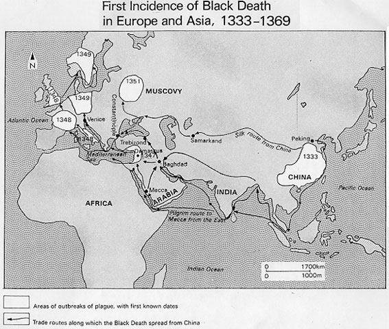
- Black Death, a map of the spread of the plague (using arrows or colors) would be great, and they seem to be common in all of the books I have read.--Dmcdevit 20:43, 22 Mar 2005 (UTC)
- I think Image:Bubonic plague map.PNG covers this nicely. ¦ Reisio 01:51, 17 October 2005 (UTC)
- That map is already included in the article. I believe the requestor was looking for a map similar to this one showing global spread. --NormanEinstein 13:29, 17 October 2005 (UTC)
- Sverre I of Norway - If someone could make a troop movement map, I would be very grateful Fornadan (t) 14:59, 17 July 2005 (UTC)
- Levant
- Image:Middle East Levant.jpg? ¦ Reisio 01:51, 17 October 2005 (UTC)
- That map's already included in the article and I think we can do better. --NormanEinstein 13:29, 17 October 2005 (UTC)
- Migration Period, map is in German
- Seleucid Empire could really use a map on par with the Roman Empire map of Wikipedia. Fred26 08:21, 19 September 2005 (UTC)
Re-creation requests
Note: the following offline images are not available under the GFDL. It is requested that they be re-created and uploaded. These requests were moved from Wikipedia:Image recreation requests. – Quadell (talk) (sleuth) 20:14, Mar 8, 2005 (UTC)
- [1] - 14 maps of France during the Hundred Years' War. Neutralitytalk 23:01, Feb 19, 2005 (UTC)
- [2] - Same as above, but in 1328.
- [3] - Italian towns and towns around 1000 CE. Neutralitytalk 23:19, Feb 19, 2005 (UTC)
- [4] - Same as above, but in 1494. Neutralitytalk 23:19, Feb 19, 2005 (UTC)
- [5] - The division of Charlemagne's empire among his sons. Neutralitytalk 23:20, Feb 19, 2005 (UTC)
- [6] - The unification of France. Neutralitytalk 23:22, Feb 19, 2005 (UTC)
- [7] - The travels of Ferdinand and Isabella. Neutralitytalk 23:24, Feb 19, 2005 (UTC)
- [8] - The Italian Wars with battle sites. Neutralitytalk 23:24, Feb 19, 2005 (UTC)
- [9] - Religion in Europe, 1555. Neutralitytalk 23:26, Feb 19, 2005 (UTC)
- [10] - Expansion of Sweden. Neutralitytalk 23:26, Feb 19, 2005 (UTC)
- [11] - Expansion of Russia to the west in eastern Europe. Neutralitytalk 23:26, Feb 19, 2005 (UTC)
- [12] a map of Köppen climate classification. --Kentin 12:41, 15 March 2006 (UTC)
![[2]](http://www.geocities.com/patricia_d_hernandez/TheHundredYearsWar.gif)
![[3]](http://wps.ablongman.com/wps/media/objects/262/268312/art/figures/KISH188.jpg)
![[4]](http://wps.ablongman.com/wps/media/objects/262/268312/art/figures/KISH_11_255.gif)
![[5]](http://wps.ablongman.com/wps/media/objects/262/268312/art/figures/KISH_08_188.gif)
![[6]](http://wps.ablongman.com/wps/media/objects/262/268312/art/figures/KISH259.jpg)
![[7]](http://wps.ablongman.com/wps/media/objects/262/268312/art/figures/KISH262.jpg)
![[8]](http://wps.ablongman.com/wps/media/objects/262/268312/art/figures/KISH265.jpg)
![[9]](http://wps.ablongman.com/wps/media/objects/262/268312/art/figures/KISH_13_309.gif)
![[10]](http://wps.ablongman.com/wps/media/objects/262/268312/art/figures/KISH308.jpg)
![[11]](http://wps.ablongman.com/wps/media/objects/262/268312/art/figures/KISH_14_324.gif)
![[12]](http://www.letras.up.pt/geograf/geofis/climas_Koppen.JPG)
Batch requests
The following are lists of articles which could use maps created in a systematic fashion.
United States Municipalities
Coordinated on User:Seth Ilys/Dot Project.
- Lowell, Indiana
- Marine City, Michigan - needs a dotmap on the page (Bghurricane11 23:12, 6 April 2006 (UTC))
Cities
Most cities outside of the U.S. could use locator maps similar to those being made as part of the User:Seth Ilys/Dot Project. The following cities had been listed in individual articles above.
- Mito, Yamaguchi
- Nihonmatsu (Japan)
- Valencia, Venezuela
- Qianjiang (China)
- Saudi Arabian major cities: Dhahran, Ras Tanura, Khobar, Dammam, Jeddah, Abqaiq, Qatif and Riyadh; other smaller cities also need maps
- Tilbury, Ontario, reference includes Chatham-Kent, Ontario - user en:XAXISx, 19:32, 1 August 2005 (UTC).
- Dhaka Kappa 00:55, 4 January 2006 (UTC)
Historical regions of the United States
Canada
- Past Canadian electoral districts (including historical provincial, territorial and colonial-era)
- I need a base map of the Pacific Northwest, showing only rivers and maybe intl/state boundaries (no cities or other modern stuff). This will be used to construct the variations on the competing Oregon Dispute claims, the routes of the Oregon Trail, the HBC Brigade and Express Routes, various First Nations trails, the Okanagan Trail, Douglas Trail and Cariboo Road, etc.; and other items needing a full-regional map; instead of one "stopping" at the 49th Parallel. Ideally this map should start at about 41 degrees north (just south of the CA-OR/ID-UT boundary and west of Helena or Great Falls (to show part of Alberta). Been looking around the Commons but can't find anything suitable. Skookum1 20:14, 22 January 2006 (UTC)
Newfoundland and Labrador
- Map showing an outline of the Great Northern Peninsula.
- Map showing the location of Isthmus of Avalon.
Seas, bays, and gulfs of the world
U.S. Roads
- List of Interstate Highways
- List of U.S. Highways
- National Auto Trail
- Boston Post Road (and probably a lot of other US roads past and present)
Europe
- Historic regions
- Medieval feudal states of Europe, more specifically: (Aquitaine, Bavaria, Brandenburg, Burgandy, Flanders, Friesland, Ile de France, Provence, Saxony, Toulouse, Connacht, Mide, Munster, etc.)
- Cities of Italy: e.g. Turin (needs a local map)
- Regions of Italy - e.g. Tuscany - needs an interior map
- Prigorodny District, Republic of North Ossetia-Alania, and other districts
{reqimage} --Sabs1285 19:58, 31 January 2006 (UTC)
Wars
- Wars where territory changed hands, e.g.:
- And Treaties and Peaces:
Rivers
Most river articles don't have maps yet. See Category:Rivers.
Some examples:
Historical blank world maps
A general request for more historical blank world maps done in the style of Vardion's world map. There is already WWI, WWII and 1985 listed on Wikipedia:Blank maps but there are surely other historical periods where there were different borders. (middle ages?/dark ages?/roman empire?/napoleonic wars?) These are useful for all sorts of historical-related subjects. -- Astrokey44|talk 06:09, 14 April 2006 (UTC)
Explorers
None of the Age of Discovery explorers have maps! Not even Christopher Columbus! It would be incredibly useful for someone to to make maps of where they went, and perhaps maps of the world with all explorers from a certain time period. However, this is truly a batch rrequest because they all need to be consistant. Don't do only one.
Category: Explorers should give you a place to start. If anyone has a concern, I'm HereToHelp (talk) 13:20, 5 November 2005 (UTC)
History of India
These articles would be using maps based on the same template, hence included in batch requests. This is a part of History of India wikiproject. Help would be highly appreciated.
list: Template:HOIOpenTasks/Maps
Orphan maps
- Lupin assisted by his LupinBot has taken up large amounts of Wiki disk space with his GBdot maps. Many of them are currently orphans. I have given my reservations to these maps at User talk:Lupin#Dotty maps. These are mainly the large size of the maps and the unhelpful names. Does anyone share my concerns? -- RHaworth 08:39, 2005 Jun 2 (UTC)
- I agree that they're much too big. If he sized them down they'd be fine for using in UK towns articles, but currently they're of no use to Wikipedia. Polocrunch 18:05, 31 March 2006 (UTC)
- Yikes, I agree, those are way too big. I get antsy when my maps pass 50k! --Golbez 21:12, 31 March 2006 (UTC)
- If there are any Scottish ones in there then they can get deleted. Discussion on infobox maps north of the border took place on the Scottish Wikipedians' notice board a wee while ago and we came up with a standard which is all hosted in a category on the commons. Due to some views that the maps should be high res those ones are ~200k as well, but they do contain a lot more detail than the flat green lupin maps. There are plenty of Scottish lupin maps that are now orphans, and the ones that aren't could do with having new commons maps created. SFC9394 23:10, 10 April 2006 (UTC)