Crimea
From Free net encyclopedia
| |||||
| Image:LocationCrimea.PNG | |||||
| Image:Map of Ukraine political simple Oblast Krim.png | |||||
| Motto: "Процветание в единстве" - 'Prosperity in unity' | |||||
| Anthem: "Нивы и горы твои волшебны, Родина" - 'Your fields amd mounts are wonderful, Motherland' | |||||
| Capital | Simferopol | ||||
| Largest cities | Simferopol, Eupatoria, Kerch, Theodosia, Yalta | ||||
| Official language | Ukrainian. Crimean Tatar and Russian are also used. | ||||
| Government | autonomous republic within Ukraine | ||||
| Head of State | the President of Ukraine Viktor Yushchenko | ||||
| Prime Minister | Anatoly Burdyugov | ||||
| Speaker of the Parliament | Boris Deych | ||||
| Area | 26,200 km² | ||||
| Population | 1,994,300 (2005) | ||||
| Currency | Ukrainian hryvnia (UAH) | ||||
| Internet TLD | .crimea.ua | ||||
| Calling code | +380-65 | ||||
| Time zone | UTC+2 | ||||
Crimea /kraɪˈmia/ or the Autonomous Republic of Crimea (Template:Lang-uk, Template:Lang-ru, Template:Lang-qr) is an autonomous republic of Ukraine on the northern coast of the Black Sea and a peninsula of the same name.
The area of the republic is 26,200 km². Its population is 1,994,300 inhabitants (2005). The capital of Crimea is the city of Simferopol.
It is home to the Crimean Tatars, who now comprise thirteen percent of the population.
Contents |
Etymology of the name
- Main article: Name of Crimea
The name Crimea derives from the name of the city of Qırım (today's Stary Krym) which was a capital of the Crimean province of the Golden Horde. Qırım is a Crimean Tatar for "my hill" (qır - hill, -ım - my). However, there are other versions of the etymology of Qırım. Russian Krym is a Russified form of Qırım. The ancient Greeks called Crimea Taurica or Taurida.
History
- Main article: History of Crimea
Early history
The earliest inhabitants of whom we have any authentic traces were the Cimmerians, who were expelled by the Scythians during the 7th century BC. A remnant that took refuge in the mountains became known subsequently as the Tauri. In that same century, Greek colonists began to settle on the coasts, e.g. Dorians from Heraclea at Chersonesus, and Ionians from Miletus at Theodosia and Panticapaeum (also called Bosporus).
Two centuries later (438 BC) the archon, or ruler, of the last-named assumed the title King of Bosporus, a state that maintained close relations with Athens, supplying that city with wheat and other commodities. The last of these kings, Paerisades V, being hard pressed by the Scythians, put himself under the protection of Mithridates VI, king of Pontus, in 114 BC. After the death of this latter sovereign, his son Pharnaces II, as a reward for assistance rendered to the Romans in their war against his father, was in 63 BC invested by Pompey with the kingdom of Bosporus. In 15 BC it was once more restored to the king of Pontus, but henceforward ranked as a tributary state of Rome.
Image:Hersones Crimea Sevastopol.jpg
During the succeeding centuries Crimea was overrun or occupied successively by the Goths (AD. 250), the Huns (376), the Bulgars (6th century), the Khazars (8th century), Kievan Rus (10th-11th centuries), the Byzantine Greeks (1016), the Kipchaks (1050), and the Mongols (1237).
In the mid 10th century eastern Crimea was conqured by Sviatoslav I of Kiev and became part of Kievan Russian Tmutarakan. In 988 Vladimir I of Kiev also captured the Byzantine town of Chersones and later converted to Christianity there.
In the 13th century the Genoese seized the settlements which their rivals the Venetians had made on the Crimean coasts and established themselves at Cembalo, Soldaia, and Caffa.
Crimean Khanate
- Main article Crimean Khanate
Meanwhile the Turkic peoples, now known as Crimean Tatars, had been living around the peninsula since the Huns. A small enclave of the Karaims dwelt among the Crimean Tatars, principally in Çufut Qale. After the destruction of the Golden Horde by Timur, they founded an independent Crimean Khanate in 1441 under Haci I Giray, a descendant of Genghis Khan. He and his successors reigned first at Qırq Yer, and from the beginning of the 15th century, at Bakhchisaray.
The trading towns in the Genoese hold were conquered by the Ottoman general Gedik Ahmet Pasha in 1475. After 1475, the Crimean Khans ruled as tributary princes of the Ottoman Empire until 1774 when they fell under Russian influence. Later in 1783, the whole of Crimea was annexed by the Russian Empire.
Russian Empire
The Crimean War, which took place between 1854 and 1856, devastated the economic and social structure of Crimea. Crimean Tatars had to leave their homeland en masse, forced by the conditions created by the war, persecution and land confiscation. Those who survived the trip, famine and disease resettled in Dobruja, Anatolia, and other parts of the Ottoman Empire. For the first time in history, Crimean Tatars became a minority in their own land, with the majority living in the diaspora. Finally, the Russian government decided to stop the process, as the agriculture began to suffer owing to deserted fertile lands. During the Russian Civil War Crimea was a stronghold of the anti-Bolshevik White Army, and in Crimea the Russian Whites led by General Wrangel made their last stand against the Red army in 1920.
Soviet Union
In 1921 the Crimean Autonomous Soviet Socialist Republic was created as part of Russian SFSR.
Crimea was the scene of some of the most bloody battles in World War II. The Germans suffered heavy casualties as they tried to advance through the isthmus linking Crimea to the Ukrainian mainland at Perekop in the summer of 1941. Once the German army broke through, they occupied most of Crimea, with the exception of the city of Sevastopol (given the title of Hero City later) which held out from October 1941 until July 4, 1942, when the Germans finally captured the city. From 1 September 1942 the peninsula was administrated as the Generalbezirk Krim (general district of Crimea) und Teilbezirk 'and sub-district' Taurien by the Nazi Generalkommissar Alfred Eduard Frauenfeld (b. 1898 - d. 1977), under the authority of the three consecutive Reichskommissare for the whole Ukraine.
In 1944 Sevastopol was liberated by Soviet troops. On 18 May 1944 the entire population of the Crimean Tatars were forcibly deported by Stalin's Soviet government as a form of collective punishment on grounds that they cooperated with the Nazi occupation forces. On 21 May 1944, the ethnic cleansing of Crimea was complete. An estimated 46% of deportees died from hunger and disease. In 1967, the Crimean Tatars were rehabilitated, but they were banned from legally returning to their homeland until the last days of the Soviet Union.
The Crimean Autonomous Soviet Socialist Republic was abolished in 1945 and transformed into Crimean Oblast (province) of the Russian SFSR. In 1954, it was transferred from the Russian SFSR to the Ukrainian SSR. As it stated in the Supreme Soviet Decree the transfer was caused by (1) geographic, (2) economic, and (3) cultural closeness to Ukrainian SSR. The transfer was also presented by the Soviet leader Nikita Khrushchev as a gesture to mark the 300th anniversary of the Treaty of Pereyaslav.
Autonomy in independent Ukraine
With the collapse of the Soviet Union, Crimea became part of the newly independent Ukraine, a situation largely unexpected by a large part of its mainly Russian population and a cause of tension between Russia and Ukraine. With the Black Sea Fleet based on the peninsula, worries of armed skirmishes were occasionally raised.
Crimea proclaimed self-rule on May 5, 1992 (disputed — see [[: talk:Crimea#{{{1|Disputed}}}|talk page]]), but later agreed to remain within Ukraine as an autonomous republic.
With the Ukraine-Russia 1997 treaties on friendship and division of the fleet, the tension slowly eased.
Government and Politics
- Main articles: Government of Crimea, Politics of Crimea
Crimea is a parlamentary republic with no president. Legislative body is the 100-seat parliament, the Supreme Rada of Crimea (sould not be confused with national Verkhovna Rada of Ukraine). The executive power is represented by the Council of Ministers with the Prime Minister at the head, wich is appointed by the Supreme Rada.
Subdivisions
- Main article: Subdivisions of Crimea
Crimea is subdivided into 25 regions: 14 raions and 11 city municipalities (officially "territories governed by city councils"). Each region consists of city, town and village communities.
- Raions:
- City municipalities:
- 15 Alushta municipality
- 16 Armyansk municipality
- 17 Dzhankoy municipality
- 18 Eupatoria municipality
- 19 Kerch municipality
- 20 Krasnoperekopsk municipality
- 21 Saky municipality
- 22 Simferopol municipality
- 23 Sudak municipality
- 24 Theodosia municipality
- 25 Yalta municipality
- 26 Sevastopol municipality is excluded from the republic of Crimea and has a scpecial legal status.
| major cities and towns in Crimea | ||
|---|---|---|
| Alupka | Alushta | Armyansk | Balaklava | Bakhchisaray | Bilohirsk | Chornomorske | Gaspra | Gurzuf | Dzhankoy | Eupatoria | Foros | Inkerman | Kacha | Kerch | Koktebel | Koreiz | Kirovske | Krasnohvardiyske | Krasnoperekopsk | Lenine | Livadiya | Massandra | Nizhnyohirskyi | Nikita | Novyi Svet | Partenit | Pervomayske | Perekop | Rozdolne | Saky | Shcholkine | Sevastopol | Simeiz | Simferopol | Sovetskyi | Stary Krym | Sudak | Theodosia | Yalta | ||
Geography
- Main article: Geography of Crimea
Crimea borders the Kherson region from the North; the rest of the border is the Black Sea in the South and West and the Sea of Azov in the East. Its area is 26,100 square kilometres. The capital is Simferopol.
Crimea is connected to the mainland by the 5–7 kilometre (3–4 mile) wide Isthmus of Perekop. At the eastern tip is the Kerch Peninsula, which is directly opposite the Taman Peninsula on the Russian mainland. Between the Kerch and Taman peninsula lies the 3–13 km (2–9 mi) wide Strait of Kerch, which connects the Black Sea with the Sea of Azov.
The Crimean coastline is broken by several bays and harbours. These harbours lie on the west side of the Isthmus of Perekop by the Bay of Karkinit; on the southwest by the open Bay of Kalamita, with the ports of Eupatoria and Sevastopol; by the Bay of Arabat on the north side of the Isthmus of Yenikale or Kerch; and by the Bay of Caffa or Theodosia, with the port of that name on the south side.
The southeast coast is flanked at a distance of 8–12 km (5–8 mi) from the sea by a parallel range of mountains, the Yayla Mountains, or Alpine Meadow mountains (also known as Yayla Dağ and the Crimean Range). These mountains are backed by secondary parallel ranges. 75% of the remaining area of Crimea consists of semiarid prairie lands, a southward continuation of the Pontic steppes, which slope gently to the northwest from the foot of the Yayla Mountains. The main range of these mountains shoots up with extraordinary abruptness from the deep floor of the Black Sea to an altitude of 600 to 750 metres (2000 to 2500 feet), beginning at the southwest point of the peninsula, called Cape Fiolente. It was this cape that was supposedly crowned with the temple of Artemis, where Iphigeneia is said to have officiated as priestess.
Numerous kurgans, or burial mounds, of the ancient Scythians are scattered across the Crimean steppes.
The terrain that lies beyond the sheltering Yayla Mountains range is of an altogether different character. Here the narrow strip of coast and the slopes of the mountains are smothered with greenery. This "Russian Riviera" stretches along the southeast coast from Cape Sarych, in the extreme south, to Theodosia and is studded with summer sea-bathing resorts such as Alupka, Yalta, Gurzuf, Alushta, Sudak, and Theodosia. During the years of Soviet rule, the resorts and dachas of this coast served as the prime perquisites of the politically loyal. In this region are also vineyards and fruit orchards; fishing, mining, and the production of essential oils are also important. Numerous Crimean Tatar villages, mosques, monasteries, and palaces of the Russian imperial family and nobles are found here, as well as picturesque ancient Greek and medieval castles.
Crimea contains the longest (96 km) trolleybus route in the world, from Simferopol to Yalta.
The city of Sevastopol is located within the republic, but has a special municipality status in Ukraine.
Economy
- Main article: Economy of Crimea
The main branches of the Crimean economy are tourism and agriculture. Industrial plants are situated for the most part in the northern regions of the republic.
Demographics
- Main article: Demographics of Crimea
By 2005 total population of Crimea is 1,994,300.
According to 2001 Ukrainian Census, the population of Crimea comprised the following self-reported ethnic groups:
- Russians - 58.32%
- Ukrainians - 24.32%
- Crimean Tatars - 12.1%
- Belarusians - 1.44%
- Tatars - 0.54%
- Armenians - 0.43%
- Jews - 0.22%
Other minorities are Poles, Azerbaijanis, Koreans, Greeks, Germans, Roma people.
Even though the Ukrainian language is the single official state language countrywide, and is therefore the sole language of government elsewhere in the Ukraine, this does not apply in Crimea, where government business is still carried out in Russian. Limited attempts to expand the usage of Ukrainian in education and government affairs have so far been less successful in Crimea than in other largely Russophone areas of the nation. Other language widely spoken is Crimean Tatar. According to the census mentioned above 77% of Crimean inhabitants named Russian as their mother tongue, 11.4% - Crimean Tatar and 10.1% - Ukrainian.
See also
- Crimean Tatars
- Krymchaks
- Karaims
- Crimean Goths
- Crimean campaigns
- Crimean War
- Black Sea Fleet
- Artek
- Koktebel Jazz Festival
Trivia
- Crimea is also the name of a fictional country in the video game series Fire Emblem
- P. D. Q. Bach (Peter Schickele) wrote a piece of "music" titled "Crimea River" (Cry me a river) about an alleged river in the Crimea.
References
- This article incorporates text from the Encyclopædia Britannica Eleventh Edition{{#if:{{{article|}}}| article {{#if:{{{url|}}}|[{{{url|}}}}} "{{{article}}}"{{#if:{{{url|}}}|]}}{{#if:{{{author|}}}| by {{{author}}}}}}}, a publication now in the public domain.
External links
- Official Crimea portal (in English, Ukrainian, Russian, and French)
- Autonomous Republic of Crimea - Information card
- WikiTravel Guide to Crimea
- Trekking in Crimea
- United Nations Crimea Integration and Development Programme
- Crimean Aspects Online news service of Cremia Tatars in English
- Kirimtatar.Net Crimean Tatar history, culture, language (in Tatar language)
- Cremia tatar portal: Tatar.Net
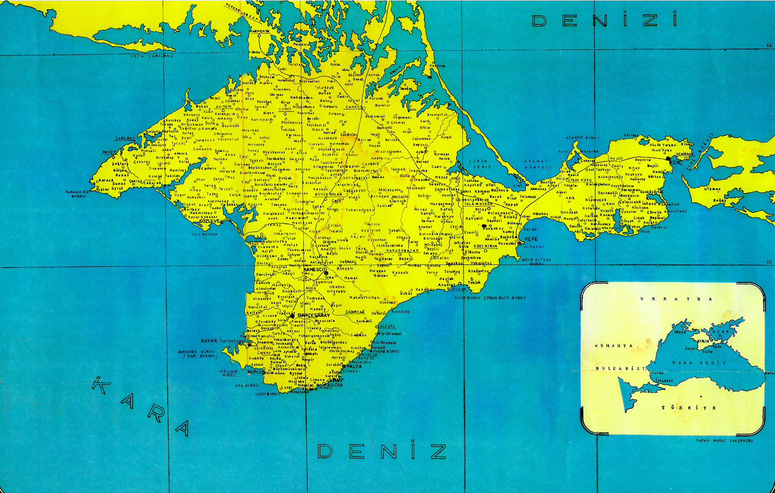
- Old map of Crimea
- The Khan Palace in Bakhchisaray
- Satellite view of Crimea (interactive)
| Subdivisions of Ukraine | Image:Flag of Ukraine.svg | ||
|---|---|---|---|
| Oblasts: | Cherkasy | Chernihiv | Chernivtsi | Dnipropetrovsk | Donetsk | Ivano-Frankivsk | Kharkiv | Kherson | Khmelnytskyi | Kirovohrad | Kiev | Luhansk | Lviv | Mykolaiv | Odessa | Poltava | Rivne | Sumy | Ternopil | Vinnytsia | Volyn | Zakarpattia | Zaporizhia | Zhytomyr | ||
| Autonomous republic: | Crimea | ||
| Cities with special status: | Kiev | Sevastopol | ||
bg:Крим cs:Krym de:Krim eo:Krimeo es:Crimea et:Krimm eu:Krimea fi:Krim fr:Crimée he:חצי-האי קרים it:Crimea ja:クリミア半島 ja:クリミア自治共和国 ka:ყირიმი ko:크림 공화국 la:Crimaea lt:Krymas mo:Кримея nl:Krim no:Krim os:Хъырым pl:Krym pt:Criméia ro:Crimeea ru:Крым sv:Krim tr:Kırım tt:Qırım uk:Автономна Республіка Крим wa:Crimêye zh:克里米亚