Interstate 580 (California)
From Free net encyclopedia
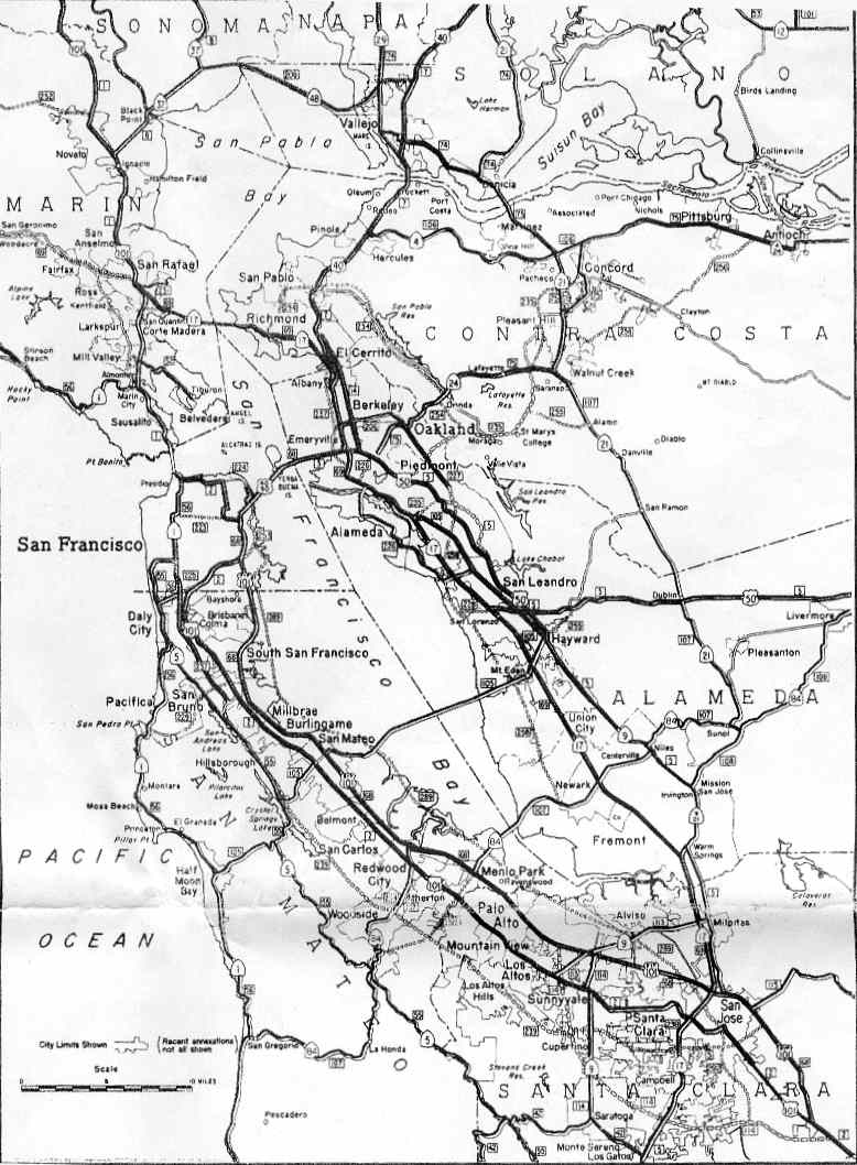
Interstate 580 (abbreviated I-580) in northern California is a heavily traveled, fairly long spur route of Interstate 80 that connects the San Francisco Bay Area to Interstate 5 in the state's Central Valley. A portion of I-580 is called the MacArthur Freeway.
Contents |
Route description
The western terminus of I-580 is north of San Francisco in San Rafael, at a junction with U.S. Route 101. The eastern terminus is with I-5 southeast of Tracy. It was named after General Douglas MacArthur in 1968. Leaving San Rafael, I-580 runs next to the San Quentin State Prison before crossing San Francisco Bay over the Richmond-San Rafael Bridge. The road then passes Point Richmond and follows a right-of-way formerly named Hoffman Boulevard, once designated Route 17. In Albany I-580 joins I-80 and then splits five miles later in Oakland. The route roughly parallels Macarthur Boulevard, formerly the route of 580's predecessor US 50, toward San Leandro and in Castro Valley turns eastward toward Dublin Canyon. 580 descends into Dublin and Pleasanton, and then after Livermore it enters the Altamont Pass. The road emerges in the Central Valley near Tracy, where, after I-205 splits near the Altamont Speedway, it turns southeastward and terminates by merging with Interstate 5 near Patterson.
History
Much of I-580, from near Tracy to Oakland, follows the general alignment of the transcontinental Lincoln Highway, later U.S. Route 50 in that area. This (and other roads) had been defined as Legislative Route 5 in 1909, forming a two-pronged route from Stockton west over Altamont Pass to Hayward, where it split towards Santa Cruz and Oakland:<ref>California Highways: Pre-1964 Legslative Route 1964</ref><ref>1963 State Highway Map</ref>
- State Route 17 from Santa Cruz to San Jose
- Oakland Road, Main Street, Milpitas Boulevard and Warm Springs Boulevard (replaced by Interstate 680) from San Jose to Warm Springs
- State Route 262, Mission Boulevard and State Route 238 from Warm Springs to near Hayward (SR 262 west to Interstate 880 was a spur of pre-1964 Legislative Route 69, now I-880)
- Present I-580 and Interstate 80 from near Hayward to the east end of the San Francisco-Oakland Bay Bridge
- Present I-580, Interstate 205 and Interstate 5 (along El Dorado Street) from Hayward to Stockton, where it turned east on State Route 4 to end at pre-1964 Legislative Route 4 (now State Route 99).
- In 1933, an extension was added from Stockton east to present State Route 49 at Mokelumne Hill, and it was further extended to present State Route 104 at West Point in 1963. This is now State Route 26.
For details on the sections that are not I-580, see the articles on State Route 17, Interstate 680, State Route 262, Mission Boulevard, State Route 238, Interstate 205 and State Route 26. For detailed history of the I-580 section, see Lincoln Highway in California.
The Lincoln Highway was designated in late 1913 along this road from Jack London Square in downtown Oakland via Hayward to French Camp (south of Stockton), the original end of Route 5, where it ran north on Route 4 to Sacramento. In late 1926, U.S. Route 48 was designated along the part of Route 5 from San Jose via Hayward to French Camp, ending at U.S. Route 101 in San Jose and U.S. Route 99 at French Camp. (The route was not marked until 1928.) The San Jose-Hayward section of Route 5 was designated as U.S. Route 101E ca. 1929, as was the Hayward-Oakland section, truncating US 48 at Hayward. Also around that time, Route 4 was relocated to the east of French Camp, and Route 5 was extended northeast to Stockton.
Around 1931, US 48 became part of a western extension of U.S. Route 50, running south on Route 4 from Sacramento to Stockton and then west on Route 5 via Hayward to Oakland.
Route 5 from Oakland to west of Tracy and present I-580 and State Route 132 to Modesto (pre-1964 Legislative Route 110) was added to the planned Interstate Highway System on August 7, 1947. In May 1957, the planned I-5 was moved west from State Route 99 to its present alignment, and I-580 was truncated to I-5 east of Tracy. Interstate 205 was added on November 8, 1957.
The number Interstate 5W was applied to present I-580, as well as present Interstate 505, on August 14, 1957. It kept this number until July 1, 1964, when California executed its 1964 renumbering.<ref name="cah Interstates"/> Route 5, and all other pre-1964 legislative routes, were replaced with existing or new signed numbers, including I-580 from south of Tracy to Oakland. I-580 had been signed as U.S. Route 50 west of the I-205 split near Tracy; this was truncated to Sacramento.
In April 1978, Interstate 180 was assigned to the spur from Interstate 80 in Albany northwest and west over the Richmond-San Rafael Bridge to U.S. Route 101 in San Rafael. This was signed as State Route 17, and in 1984 it was transferred to an extension of I-580 (number approved by AASHTO in June 1983 because of conflicts with State Route 180).
Truck ban through Oakland
I-580 is the only Interstate freeway not open to trucks.<ref>Interstate 580 Truck Restriction History, CalTrans.</ref> Trucks over 4.5 tons are prohibited through Oakland between Grand Avenue and the San Leandro border. Instead, they are instructed to take Interstate 880 and Interstate 238.
The truck prohibition has been in effect since the freeway was built in 1963 as part of U.S. 50. Both the Federal Highway Administration (FHWA) and the California Department of Transportation (CalTrans) imposed the restriction, partly because the City of Oakland already had a truck ban through the area prior to the freeway's construction. Since then, the restriction was grandfathered in when the freeway was both renumbered and added to the Interstate Highway System.
For decades, the trucking industry lobbied to have the ban removed, but was unsuccessful due to local opposition. In 2000, the California State Legislature passed Assembly Bill 500, adding the I-580 truck restriction into the California Vehicle Code.<ref>California Assembly Bill 500</ref> However, the California Highway Patrol has frequently allowed trucks through temporarily when major accidents occur on I-880 or I-238.
Major cities/towns along route
- San Rafael
- Richmond
- Albany
- Berkeley
- Emeryville
- Oakland
- San Leandro
- Castro Valley
- Dublin
- Pleasanton
- Livermore
- Tracy
Intersections with other interstates
- Joins Interstate 80 in Albany
- Separates from I-80 in Emeryville (junction is also the north terminus of Interstate 880)
- This intersection is known as the MacArthur Maze
- Interstate 980 (northern terminus of I-980) in Oakland
- Interstate 238 (eastern terminus of I-238) in Castro Valley
- Interstate 680 in Pleasanton
- Interstate 205 (western terminus of I-205) between Livermore and Tracy
- Interstate 5 southeast of Tracy
Notes
- On the section of 10-lane freeway that is designated both I-80 and I-580, from Emeryville to Albany, the two routes are labeled with opposite directions – that is, while a vehicle is physically moving north on the road, it is on both I-80 East and I-580 West.
- The Dublin/Pleasanton Line of the Bay Area Rapid Transit runs in the freeway's center median between the Interstate 238 interchange and the Dublin/Pleasanton Station.
State law
Legal definition of Route 580: California Streets and Highways Code, Chapter 2, Article 3, Section 618 Template:CAScenicAlt
Exit list
Note that postmiles increase from east to west, the reverse of the exit numbers. This is because Interstate 580 assimilated much of what was Highway 17 and Interstate 5W, both south-north highways.
| #<ref>Cal-NExUS Interchange Exit Numbering</ref> | Postmile<ref name="bridge log"/> | Municipality | Destinations | Notes | |
|---|---|---|---|---|---|
| 1A | MRN 4.78 | 0.00 | San Rafael | Image:US 101 (CA).svg U.S. Route 101 north - San Rafael; Santa Rosa | westbound exit and eastbound entrance |
| 1B | MRN 4.50 | 0.28 | Image:US 101 (CA).svg to U.S. Route 101 south - Francisco Boulevard; San Francisco | exit 1 eastbound | |
| 2A | MRN 3.29 | 1.49 | Sir Francis Drake Boulevard | westbound exit and eastbound entrance | |
| 2B | MRN 2.63 | 2.15 | Francisco Boulevard - San Quentin | exit 2 eastbound | |
| Richmond-San Rafael Bridge (toll westbound) | |||||
| 7A | CC 6.01 | 6.56 | Richmond | Western Drive - Point Molate | no eastbound exit |
| 7B | CC 5.11 | 7.46 | Image:California 93.svg Richmond Parkway to Interstate 80 east - Port Richmond (proposed State Route 93) | exit 7 eastbound | |
| 8 | CC 4.64 | 7.93 | Canal Boulevard; Garrard Boulevard | ||
| 9 | CC 3.79 CC 3.60 | 8.78 8.97 | Harbour Way; Cutting Boulevard | split into 9A and 9B westbound | |
| 10A | CC 2.89 | 9.68 | Marina Bay Parkway; South 23rd Street | ||
| 10B | CC 2.09 | 10.48 | Regatta Boulevard | ||
| 11 | CC 1.21 | 11.36 | Bayview Avenue | ||
| 12 | CC 0.24 | 12.33 | Central Avenue | ||
| 13 | Albany | Buchanan Street | eastbound exit and westbound entrance; other ramps are on I-80 | ||
| ALA 47.35 | 13.26 | Image:Interstate 80 (California).svg Interstate 80 east - Vallejo; Sacramento | westbound exit and eastbound entrance; I-80 joins eastbound and leaves westbound | ||
| Concurrent with Interstate 80 | |||||
| 19A | ALA 46.95 | 17.66 | Oakland | Image:Interstate 80 (California).svg Interstate 80 west - San Francisco | I-80 joins westbound and leaves eastbound |
| ALA 46.53 | 18.08 | Image:Interstate 880 (California).svg Interstate 880 south - West Grand Avenue; San Jose; Alameda | eastbound exit and westbound entrance | ||
| 19A | ALA 45.99 | 18.62 | Image:California 123.svg MacArthur Boulevard; San Pablo Avenue (State Route 123) | left eastbound exit only | |
| 19B | ALA 45.99 ALA 45.39 | 18.62 19.22 | Image:California 123.svg West Street; San Pablo Avenue (State Route 123) | westbound exit and eastbound entrance | |
| 19C | ALA 45.15 | 19.46 | Image:California 24.svg State Route 24 east - Berkeley; Walnut Creek | exit 19B eastbound | |
| 19D | ALA 45.15 | 19.46 | Image:Interstate 980 (California).svg Interstate 980 west to Interstate 880 - Downtown Oakland | exit 19C eastbound | |
| 20 | ALA 44.81 ALA 44.51 | 19.80 20.10 | Broadway-Auto Row; Webster Street | eastbound exit only | |
| 21A | ALA 44.33 ALA 44.28 | 20.28 20.33 | Harrison Street; Oakland Avenue; MacArthur Boulevard | ||
| 21B | ALA 43.48 ALA 43.23 | 21.13 21.38 | Grand Avenue; Lakeshore Avenue | ||
| 22A | ALA 43.23 | 21.38 | Lakeshore Avenue | westbound exit and eastbound entrance | |
| 22B | ALA 42.67 ALA 42.18 | 21.94 22.29 | Park Boulevard; 14th Avenue | exit 22 eastbound | |
| 23 | ALA 41.43 ALA 41.14 | 23.04 23.33 | Fruitvale Avenue; Coolidge Avenue | exit 24 westbound | |
| 24 | ALA 40.65 | 23.82 | 35th Avenue | eastbound exit and westbound entrance | |
| 25A | ALA 40.08 | 24.39 | High Street | eastbound exit and westbound entrance | |
| 25B | ALA 39.77 | 24.86 | MacArthur Boulevard; High Street | exit 25 westbound | |
| 26A | ALA 39.24 | 25.39 | Image:California 13.svg State Route 13 - Berkeley | westbound exit and eastbound entrance | |
| 26B | ALA 38.92 | 25.71 | Image:California 13.svg Seminary Avenue to State Route 13 - Warren Freeway | exit 26 eastbound | |
| 27A | ALA 38.31 | 26.32 | Edwards Avenue | eastbound exit and westbound entrance | |
| 27B | ALA 37.80 | 26.83 | Keller Avenue; Mountain Boulevard | exit 27 westbound | |
| 29A | ALA 36.34 | 28.29 | Golf Links Road; 98th Avenue | exit 29 westbound | |
| 29B | ALA 35.71 | 28.92 | 106th Avenue; Foothill Boulevard | eastbound exit and westbound entrance | |
| 30 | ALA 35.10 | 29.53 | MacArthur Boulevard; Foothill Boulevard | westbound exit and eastbound entrance | |
| 31A | ALA 34.81 ALA 34.48 | 29.82 30.15 | San Leandro | Dutton Avenue; Estudillo Avenue | eastbound exit and westbound entrance |
| 31B | ALA 34.48 | 30.15 | Grand Avenue; Estudillo Avenue - Downtown | exit 31 westbound | |
| 32A | Benedict Drive | westbound exit only | |||
| 32B | ALA 32.84 ALA 32.72 | 31.79 31.91 | 150th Avenue; Fairmont Drive | exit 32 eastbound | |
| 33 | ALA 31.71 | 32.92 | 164th Avenue; Miramar Avenue; Carolyn Street | ||
| 34 | ALA 30.92 | 33.71 | Image:California 238.svgImage:Interstate 238 (California).svg State Route 238 - Hayward (Interstate 238) | eastbound exit and westbound entrance | |
| 34 | ALA 30.92 | 33.71 | Image:Interstate 238 (California).svg Interstate 238 north to Interstate 880 | westbound exit and eastbound entrance | |
| 35 | ALA 30.36 | 34.27 | Strobridge Avenue | ||
| 36A | ALA 29.37 | 35.26 | Redwood Road - Castro Valley | eastbound exit and westbound entrance | |
| 36B | ALA 28.75 ALA 28.41 | 35.88 36.22 | Center Street; Crow Canyon Road - Castro Valley | exit 37 westbound | |
| 39 | ALA 26.23 | 38.40 | Eden Canyon Road; Palomares Road | ||
| 44A | ALA 21.43 | 43.20 | Pleasanton | San Ramon Road; Foothill Road - Dublin | |
| 44B | ALA 20.70 | 43.93 | Image:Interstate 680 (California).svg Interstate 680 - Sacramento; San Jose | ||
| 45 | ALA 19.86 | 44.77 | Hopyard Road; Dougherty Road | ||
| 46 | ALA 18.82 | 45.81 | Hacienda Drive; Dublin Boulevard | ||
| 47 | ALA 17.96 | 46.67 | Santa Rita Road; Tassajara Road | ||
| 48 | ALA 16.70 | 47.93 | El Charro Road; Fallon Road | ||
| 50 | ALA 14.98 ALA 14.95 | 49.65 49.68 | Livermore | Image:California 84.svg State Route 84 - Airway Boulevard; Collier Canyon Road | |
| 52A | ALA 13.22 | 51.41 | Portola Avenue | eastbound exit and westbound entrance | |
| 52B | ALA 12.53 | 52.10 | North Livermore Avenue - Downtown Livermore | exit 52 westbound | |
| 54 | ALA 10.69 | 53.94 | First Street; Springtown Boulevard | ||
| 55 | ALA 9.68 | 54.95 | Vasco Road - Brentwood | ||
| 57 | ALA 8.29 | 56.34 | North Greenville Road; Altamont Pass Road; Laughlin Road | ||
| 59 | ALA 5.93 | 58.70 | North Flynn Road | ||
| 63 | ALA 1.48 | 63.15 | Grant Line Road - Byron | ||
| 65 | ALA 0.42 | 64.21 | Image:Interstate 205 (California).svg Interstate 205 east - Tracy; Stockton | eastbound exit and westbound entrance | |
| 67 | SJ 13.54 | 66.43 | Mountain House Parkway; Patterson Pass Road | ||
| 72 | SJ 8.15 | 71.82 | Corral Hollow Road | ||
| 76 | SJ 4.35 | 75.62 | Image:California 132.svg State Route 132 east - Modesto | eastbound exit and westbound entrance | |
| 76 | SJ 4.02 | 75.95 | Image:California 132.svg State Route 132 east - Tracy; Chrisman Road | westbound exit and eastbound entrance | |
| SJ 0.00 | 79.97 | Image:Interstate 5 (California).svg Interstate 5 south - Fresno; Los Angeles | eastbound exit and westbound entrance | ||
References
<references/>